Tormenta brings a severe thunderstorm watch to the Texas Panhandle through tonight, with the National Weather Service issuing the alert for the region until 11:00 PM CDT (May 23, 2026). The primary threats include large hail and damaging wind gusts of 60-70 mph, creating significant hazards for residents and property across the western and central Panhandle areas including Armstrong County, Randall County, and surrounding zones.
🔥 Quick Facts
- Severe Thunderstorm Watch issued May 23 at 5:08 PM CDT
- Watch effective until 11:00 PM CDT tonight
- Primary hazards: large hail and 60-70 mph wind gusts
- Covers western and central Texas Panhandle regions
- Storm system affects areas from New Mexico into Oklahoma
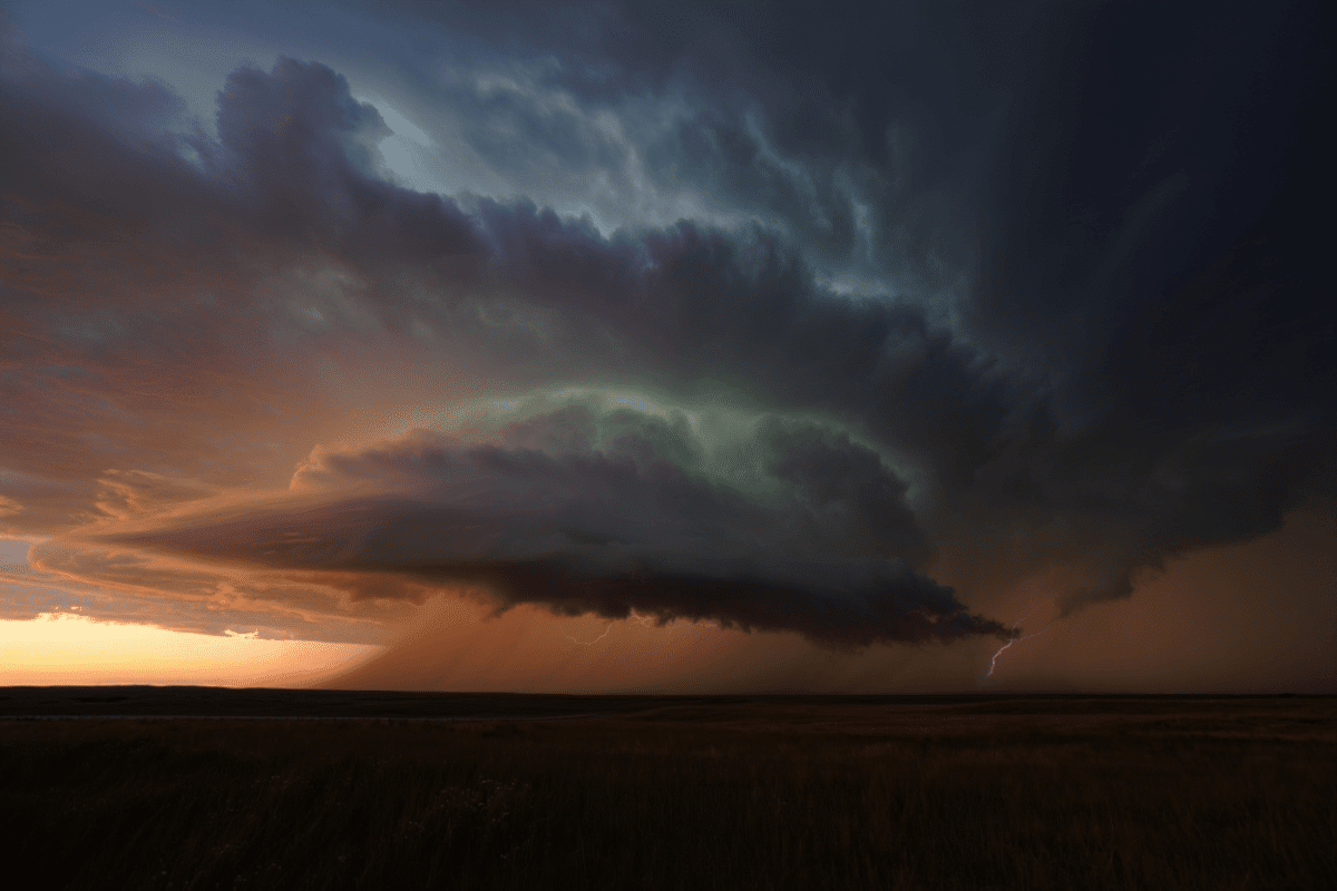
What Defines a Severe Thunderstorm Watch
A severe thunderstorm watch differs critically from a warning. According to the National Weather Service, a watch indicates conditions are favorable for severe thunderstorms to develop within a specified region and timeframe. The National Weather Service criteria for a severe thunderstorm include winds exceeding 58 mph, hail at least 1 inch in diameter, or tornadoes. Tonight’s threat elevates these hazards substantially, with forecasters predicting wind gusts reaching 60-70 mph and potentially larger hail stones.
Watches differ from warnings; a watch means conditions exist, while a warning means a storm has been sighted or indicated on radar. Residents under a watch should monitor conditions closely and have a plan to seek shelter if conditions change or a warning is issued during the night.
Tonight’s Severe Weather Threat and Setup
The severe thunderstorm watch emergence reflects a strong atmospheric setup typical of late May severe weather patterns. A cold front combined with warm, moist air from the south creates instability—the engine driving thunderstorm development. The Texas Panhandle sits at the convergence zone where these air masses collide, maximizing the risk for organized convection.
Forecasters have emphasized that large hail will be the primary threat, with wind damage as a secondary but significant concern. As storms develop and move through the region, the timing intensifies during evening hours when the atmosphere reaches peak instability. This temporal pattern—afternoon and evening peak activity—is characteristic of high-based thunderstorms in the southern plains, where the temperature-moisture profile favors organized severe weather.
Hazard Breakdown and Regional Impact
Understanding the specific hazards helps residents prepare appropriately:
| Hazard | Expected Threat | Damage Potential |
| Large Hail | Golf ball-sized (1.75″) to larger | Vehicle damage, window breakage, roof harm |
| Wind Gusts | 60-70 mph, isolated higher | Downed trees, power outages, structural damage |
| Rainfall | Heavy in isolated locations | Localized flooding, flash flood risk |
| Tornado Risk | Low to isolated | Possible with strongest cells |
The Western Texas Panhandle region—including cities like Amarillo and surrounding counties—faces the most significant exposure. The combination of severe wind and hail risks often leads to widespread power disruptions, with large trees and power lines particularly vulnerable to 60-70 mph gusts.
How to Stay Safe During the Watch Period
Severe weather watches require active preparation, not passive waiting. Residents beneath the watch should take these steps immediately: monitor local National Weather Service communication channels, have a battery-powered radio ready, identify a safe room (interior space on the lowest level, away from windows), and secure outdoor items that could become projectiles under strong winds. For those with vehicles outdoors, parking away from trees and structures reduces hail-related damage risk, though in a developing watch scenario, seeking shelter is preferable to attempting vehicle moves if storms already approach.
Check on elderly relatives, neighbors, and those with mobility challenges. Farmers should consider securing livestock and equipment. Outdoor events scheduled could require postponement if conditions escalate to warnings. Real-time radar monitoring becomes essential as evening progresses, since watch conditions can transition rapidly to Severe Thunderstorm Warnings once storms organize.
“Severe thunderstorms are possible across the Panhandles today. The primary hazards will continue to be large hail and damaging wind gusts with any storms.”
— National Weather Service Amarillo Office, Official Statement
What to expect after tonight
Following the passage of the front and dissipation of tonight’s storms, conditions should stabilize Friday. The May 2026 pattern has featured multiple rounds of severe weather across the Southern Plains, with the region experiencing above-normal severe weather frequency. Understanding that this watch is part of a broader spring pattern—not an isolated event—helps context for why panhandle residents increasingly prepare severe weather response plans year after year.
As atmospheric moisture returns and upper-level wind shear patterns continue favorable, extended forecasts suggest additional watches possible into the weekend. The Storm Prediction Center typically maintains a multi-day outlook assessing where the next significant threat emerges, critical information for communities planning outdoor activities and events.
Sources
- National Weather Service Amarillo Office – Official severe thunderstorm watch issuance and hazard assessment
- Storm Prediction Center (NOAA) – Severe weather watch criteria and risk categorization
- NWS Warning Criteria Guidelines – Technical definitions for severe thunderstorm warnings and watches